Plat Maps of the early 1800s'
Community of Crowson's Cove
Sevier County, Tennessee:
An Ongoing Project

Updated 3 Dec 2009


New!  Edd Clardy's Crowson genealogy notes and local newspaper articles


By the way, you must
pronounce the "Crow" in "Crowson"
to rhyme with HOW, NOW, or COW, not SHOW, JOE, or DOUGH.
Don't ask me why. The dear people in the Sevier Co. Library didn't know why, either.
(They just told me that was how the Crowsons said it and not to mispronounce it around any of them.  OK?  ;-)


Return to Isham Gwin's page Return to the Genealogy Home Page

We started this project to help us find where in Sevier Co., TN, this community was located and perhaps let us find some of our missing relatives' graves.  In particular, we wanted to know where Isham Gwin's farm was. Now that we have proven its location, we want to continue the project to find as much as possible about our ancestors' home.

For the most part, we're using Land Grant Deeds to the various properties, which deeds contain written survey instructions (as well as other important information, such as the names of neighbors with adjoining land, etc.) of the respective properties. I've been using those instructions to make these maps. (For a tutorial in how one might do that oneself, please go to my Isham Gwin page and follow the links or go directly to the tutorial page itself.)

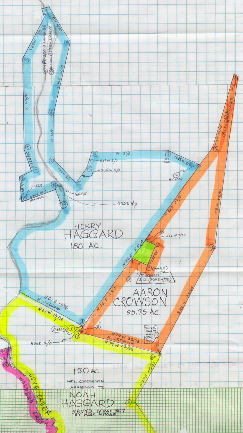
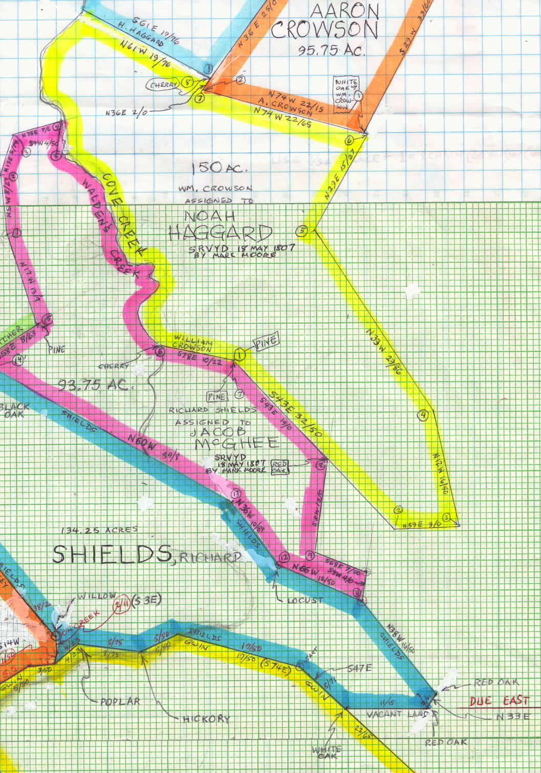
So, where was Crowson's Cove? That was the big question for years, according to George and Juanita Fox, because almost all of the deeds that have "in Crowson's Cove" in them also say "on the waters of Walden's Creek," and everyone knows that Walden's Creek is the next hollow to the north from Wear's Cove. But now we know and have proven that Crowson's Cove was another name, perhaps the first English name, for today's Wear's Cove. And George had a theory that we now know is true, that today's Cove Creek was originally called Walden's Creek, and that the names of many of the waterways in the area were changed right around the time most of these grants were surveyed. (1) He found an early map of the area dated about the same time as these deeds, and on it, today's Cove Creek is clearly labeled Walden's Creek. (2) Indeed (no pun intended!), when you get to the deeds below numbered four and five--to Jacob McGhee and Noah Haggard, respectively--notice that both properties share a common border, the creek itself.  Yet on one deed it is called Cove Creek, and on the other, Walden's Creek--and what's more, both surveys were done on the same day and by the same person! (3) The deed for what is called the "Meeting House" on neighbor Peter Brickey's deed is actually made out in the name of the congregation of the Wear's Cove Baptist Church. (4) In July of 2004, I traveled to Sevierville (the Sevier County Genealogy Library there under the direction of Mr. Sam Maner and his excellent staff) and Wear's Cove and found proof that the map I made (shown in segments below) fits almost exactly (within just a few feet) with the USGS map of Wear's Cove enlarged to the same scale as my map.

John Gwin
Updated 4 Dec 2004

NOTE: I'm told that these maps may take quite a long time to load, depending on how fast your machine is and how many other applications you have open.


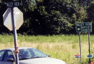
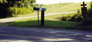
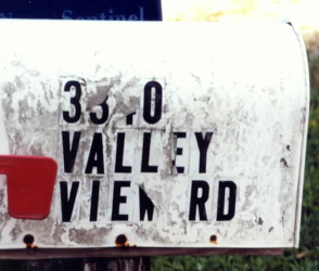
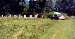
OK. How do I get there?From Sevierville, the seat of Sevier Co., TN, drive south on U.S. 441 about four miles to the junction of U.S. 321, which take to the right. Almost three miles later, you'll pass Walden's Creek Road on your right--don't turn there! Continue on up the hollow into Wear's Cove or Wear's Valley. About three miles later, when you come to the little community of Hatchertown, you'll be in the north end of Crowson's Cove. 

You'll see Valley View Road to the left with another sign pointing the way to Valley View Baptist Church (see first picture). Take this left, then a few hundred yards later at a mailbox marked "3340 Valley View Rd." (see second and third pictures), follow the fenceline up the rise to your right on the grass road. This will level out atop the hill and curve around to the left, leading to the little cemetery you see in the next pictures.
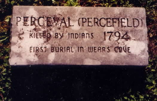
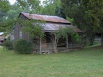
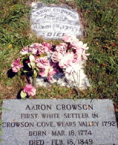
This is the Crowson Cemetery with Aaron Crowson's grave in it (far right). His gravestones--the older one above, the newer one below--read, respectively: 

"AARON CROWSON BORN MARCH 18, 17?? DIED ????"
and
"AARON CROWSON -- FIRST WHITE SETTLER IN CROWSON COVE WEARS VALLEY 1792 -- BORN MAR.18, 1774 -- DIED FEB. 18, 1849."
Other stones include that of "PERCEVAL (PERCEFIELD) -- KILLED BY INDIANS 1794 -- FIRST BURIAL IN WEAR'S COVE." (But see the 1972 "Legend" article below for newer information.)

You'll be standing on the western edge of Aaron Crowson's 95.75-acre property just south of the property marked in green and labeled "Brumley and Company" (see map SEGMENT ONE, Plat(2) below). [John M. Gwin Note:  Some new information (the 1972 "Indians" article listed below) names a "Clabo's Store" that could be the descendant of this 1807 "Brumley and Company" enterprise.]

..
.


Names of Families Known to Have Owned Land in Crowson's
Plats I've Already Mapped Below


Plats I've Not Yet Mapped
(Boldface names represent deeds we now have and
for which we were platting the maps--up until about 2002.)
Not Yet Mapped


Bennifield, 
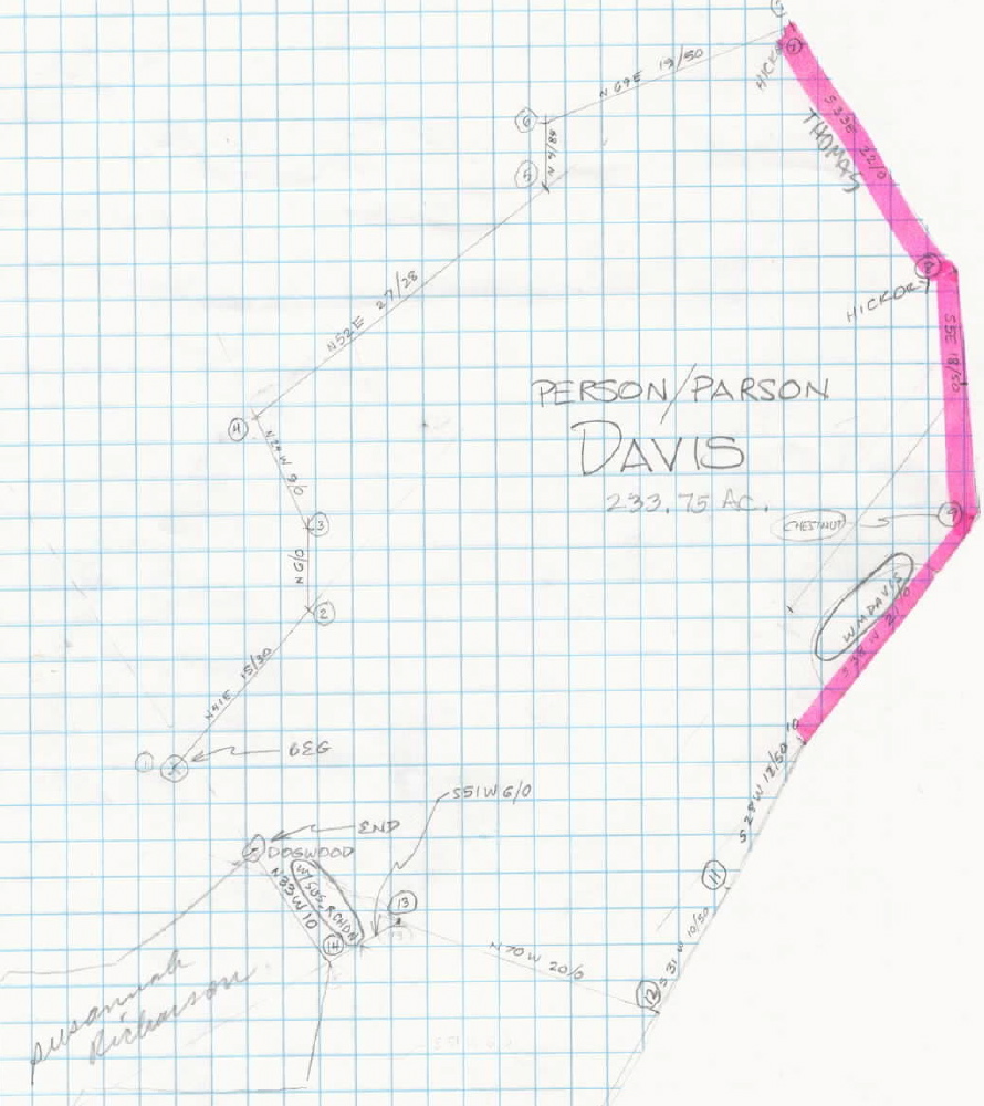
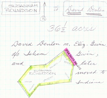
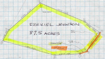
Charles
Boaz, Abednego
Brickey, Peter
Brumley
Coulter, Charles
Crowson, Aaron
Crowson, William
Davis, Parsons 
Davis, William
Denton, David
Gwin, Isham
Haggard, Henry
Haggard, Henry (II?)
Haggard, Noah
Hatcher, William
Johnson, Ezekiel
Lovelady, William
Maddox, William
McGhee, Jacob
Richardson, Susanna
Shields, Richard
Sims, Joshua
Thomas, Jonathan
Wear's Cove Baptist Church...
.....(by William Davis)
Amerine, George
Ballard, Blan
Beatty, Samuel
Friar, John
Giddin, James
Headrick, Henry
Huskey, Jonathan
Kelly, John
 
Lovelady, Obed
McBryan, John
McLaughlin, Alexander
Miller, William
Montgomery, James
Moore, Mark
Murphy, Edward
Murphy, William
Nobles, Andrew
Ogle, Hercules
Ogle, Thomas

Parker, William

Parsons, Samuel
Partin, Mildred
Patterson, Samuel
Renfro, Mary
Riggin, James
Veatch, Kinsey

Waddle, David
Mr. Walker
Wear, Samuel


Here is a piecemeal but perhaps adequate
Overview Map
of most of the Crowson's Cove properties listed above in green.

The numbered, colored names in the gray shaded section to the right are the owners of the properties in corresponding colors in the map to the left.
Below it are seven enlarged segments of the map with notes.
Some of the notes include things that are there today.


.................................................
...........................
......................................
...........................................................................
A
|
|
|
North
|
|
|
|
|
.............


(09)   William Hatcher

(10)   Henry Haggard
(11)   Peter Brickey
(12)   Wear's Cove
...........Bapt. Ch.
(13)   Charles Coulter

(14)   William Lovelady

(17)   Abednego Boaz
 

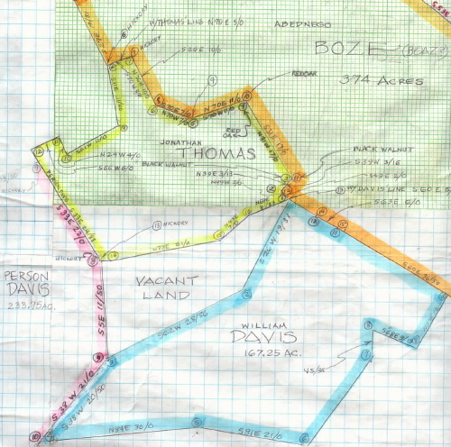
(18)  Jonathan Thomas
(19) William Davis


(01)   Henry Haggard
(02)   Aaron Crowson
(03)   Brumley & Co.


(05)   Noah Haggard
(04)   Jacob McGhee

(06)   Richard Shields

(07)   Isham Gwin


(08)   Charles Bennifield
 

(15)   Joshua Sims
(16)   William Maddox


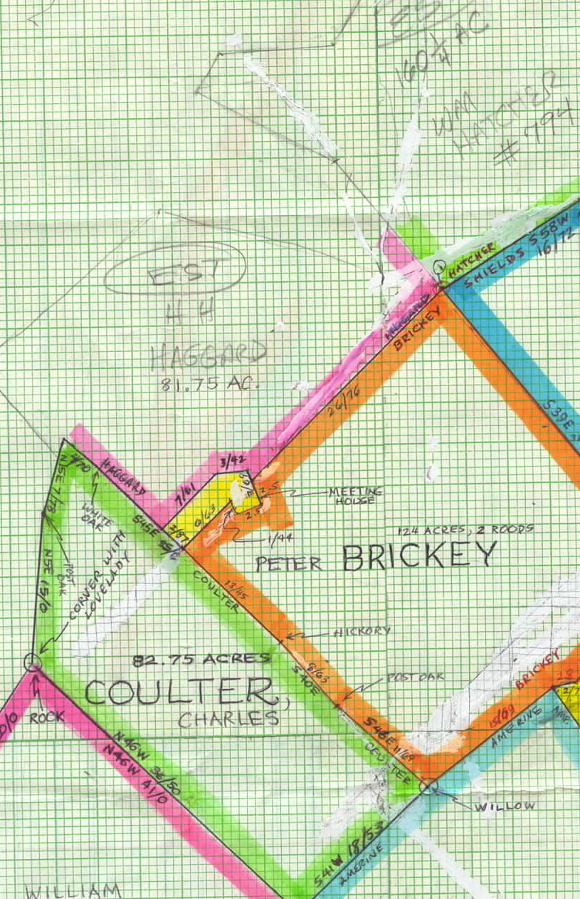
SEGMENT ONE:

(Plat 1)--This blue plat represents Henry Haggard's 180 acres, the northernmost property in Crowson's Cove I've mapped to date (15 Jun 2004). 

Cove Creek enters his land at the southwest corner and provides the southwestern boundary line. It then continues north through the "panhandle" of his property, exiting to the north to where it will eventually leave the cove and follow the hollow--actually more of a canyon cut years later through the rock for the road--before joining today's Walden's Creek and emptying into the river near Sevierville.

WHAT'S THERE TODAY: Look at Henry Haggard's blue-colored plat. Do you see the word "Hazel" with the arrow pointing to corner number 17? This is very close to the intersection today of Wears Valley Road and Valley View Road

[John M. Gwin Note: I've developed a page for this Henry Haggard, since he moved from Crowson's Cove to middle Alabama about the same time that John Gwin married Jane Walker and moved to Dallas Co., AL. This is most likely the land of Rev. Henry Hazelrigg Hatcher, Sr., who moved from here to Bibb Co., AL, where he pastored a church,  lived to his mid 90's, died, and is buried.  See plat no. 10 below.]

(Plat 2)--Aaron Crowson, the first anglo settler in the valley, lived somewhere on the 95 and 3/4 acres of land represented by this orange plat. The property is very narrow at its northern tip, measuring only one and one-half chains (ninety-nine feet).

WHAT'S THERE TODAY: Crowson lived and died in the valley, being buried here on his own land in the Crowson Cemetery (see photos, above) located somewhere just south of the southern border of what is marked in green here and labeled "Brumley and Co." In fact, Valley View Road, on my USGS map, crosses Crowson's land at approximately the same place as this southern border of Brumley's land and at exactly the same angle (S65E), leading me to believe that the road may have been there in 1807 and perhaps formed this southern boundary!

(Plat 3)--The trapezoidal property along its west-central border, represented here in green and looking to be about three acres, is said on his deed to belong to "Brumley and Co." I speculate that, due to its small size, this land was the site of some commercial enterprise, perhaps the local general store. I asked George Fox about Brumley,  and he wrote, "I looked at various records I have and found a Thomas Brumley who lived in Tuckaleechee, Blount County. Could not find any Brumley in Sevier County, but there are few records, so that doesn't prove anything." This may be the very person we're looking for, though, since Tuckaleechee Cove is just a couple of miles south of Crowson's, just across the county line. Another webpage, listing Blount County Marriages, has a BRUMLEY, Margaret, marrying a MAJOR, James, on 13-JAN-1803.


.

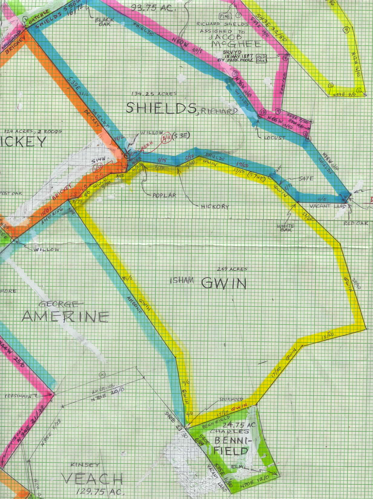
SEGMENT TWO:

(Plat 4)--The 93.75 acres represented by this mauvish plat was first owned by Richard Shields who sold it to Jacob McGhee.

Cove Creek, originally (and on this deed!) called Walden's Creek, enters the property from the southwest, crosses it northerly, and becomes its northeastern boundary, exiting at its northernmost point. 

WHAT'S THERE TODAY: This part of today's Cove Creek still follows this line almost exactly!

(Plat 5)--The property of this yellow-bordered plat was first owned by William Crowson, alleged to be the father of Aaron. William sold this land to Noah Haggard in 1807, the year of this survey, and moved with his family to Giles Co., TN.

Noah was either the son or grandson of (1)--Henry Haggard, now his next-door neighbor to the north.

.


SEGMENT THREE:

(Plat 6)--Richard Shields, whose property is represented by this blue-bordered plat, was my gggg-grandfather Isham Gwin's neighbor to the north.  I've not seen a period drawing of where Cove Creek crossed his property, but it had to be something like the penciled lines indicate, from south to north. Click here for some recent developments.

(Plat 7)--This yellow map of Isham Gwin's 249-acre property shows Cove Creek (in pencil)  entering it from the westernmost corner, continuing along its northern border, and exiting it at its northernmost point into Shields' land.

His was the first deed I found and the first map I drew in this entire project. I oriented all the others from it--i.e., I added Bennifield's plat to it using their common border as a starting point, then added Shields' in the same way, then Brickey's (orange), and continued on around in a counter-clockwise direction, using common borders to attach each to the one drawn previously.

Whatever margin of error existed, then, because of my own errors due to mistranscription of the deeds, the tiny scale of the drawings, the imprecision of my instruments, etc., was multiplied six to eight times by the time I arrived at the Kinsey Veach plat, which clearly does not yet quite fit into the puzzle.

Additionally, we've yet found neither deed nor surveyor's sketch for the George Amerine property; we've only seen his name referenced in other deeds as a neighbor of the given landowners. Nevertheless, if and when we can make Veach's plat fit, we should have a picture of Amerine's land by process of elimination, since it is surrounded by all the others.
Here are some notes from Barb Ward: "...on the internet and found George Amerine--(Land grant #336). Don't know if this is on the films you and I ordered but will check. He bought 132 acres on Cove Creek... George was a Jr.; his father was George Amerine, Sr. George Jr's grandfather, John Henry Amerine, was from Germany/Switzerland, b. 1732 and died 1805, Bedford Co., PA. That is where George Amerine was born: 1784 Bedford Co., PA, m. Luda Hulda (1802-1860), and died 29 Jan 1866, Blount Co., TN...Nathan Veach of Sevier Co. Land grant #1393. That might be on the films too. Peter Brickey (Blount Co. Land Grant #421)." 

Also, here are two marriages I found in next-door Blount Co. occurring some 40-50 years later: AMERINE, Richard, married WELLS, Serena J., on 30-JAN-1851; and AMORINE, Perlina, married ELLIS, John, on 16-DEC-1855.

WHAT'S THERE TODAY: In July 2004 I visited the Sevier County Genealogical Library in Sevierville, TN, and saw where someone else had already drawn similar maps to these and placed Crowson's Cove in the Wear Valley. Sure enough, the maps coincide almost perfectly (see my notes on "margin of error" two paragraphs above). The quarter circle formed by the east side of Bennifield's land and the SE side of Gwin's land, including its easternmost point, goes around a small mountain today called Buckeye Knob. The west side of Benefield's property pretty much coincides with Katy Holler Road.

Further, today's Wear Valley Road cuts through the center of Peter Brickey's land, with the gas station at the intersection of Wear's Valley and Roberson Roads being very near the geographical center of his property. Roberson Road then continues in a southeasterly direction almost parallel to and very near the line shared by Gwin and Amerine.

(Plat 8)--Charle's Bennifield's little 24.75-acre plat (green, south of Gwin's) was difficult to draw, as evidenced by he large amounts of White-Out! The difficulty came by reason of two transcription errors--one mine, the other the surveyor's. With the help of one of my 6th-grade students (thanks again, Jessica N!), we discovered mine, which made the surveyor's suddenly obvious. Bennifield is probably correctly spelled Benefield.

And while Veach's plat fits all three of its bordering properties perfectly, it doesn't fit them at the same time, which means we'll have to redo the entire map and readjust each plat until Veach's  fits.

I'm just not sure I'm up to that right now. Maybe we'll have to fudge a little bit.

.
SEGMENT FOUR:

(Plat 9)--William Hatcher (top, begun in green, in pencil) owned 160.25 acres north and east of Shields' two properties.  While I've been able to establish for certain several of the borders as being common with Shields', I've not yet been able to make the ends meet. Thus, only a penciled estimate can be shown at this time.

(Plat 10)--A similar problem exists for this 81.75-acre second property of Henry Haggard. We have the surveyor's sketch map (and thus the shape), but we've not yet seen the deed with precise survey instructions. So for now, the penciled estimate, begun in mauve, will have to do. It is not clear, however to which Henry this property belonged. We have learned that Rev. Henry Hazelrigg Haggard, Sr., was one of the first settlers in the valley, and it makes sense, then that his would be one of the first farms one would cross when entering the valley (see number one above). He may have owned this land, too; however, he also had a son, Henry Hazelrigg Haggard, Jr., who may have been the owner.

(Plat 11)--At this point let me acknowledge the invaluable assistance of TWO FRIENDS, without whose help this project would still be just an idea. The first is my cousin, Barbara Ward, who saw what I was doing and searched for, found, and sent me the copies of Peter Brickey's, Richard Shields', and Charles Bennifield's deeds. She challenged me to continue seeking to expand our knowledge of the Crowson's Cove community.

Brickey's plat appears here in orange. At that time, it was the westernmost portion of the community known to us. And now we knew that a "meeting house" existed, the property for which extended at least partially into Brickey's land, but we knew nothing else of it. 

Enter the second, George Fox, who, with his wife, Juanita, both historians and genealogists with roots in Sevier County, published the book that originally led me to (6)--Isham Gwin's deed. I'd been in touch with him a year earlier to ask permission to use portions of their book in this website (they graciously consented).

Unbeknownst to me, however, they had long been searching for the site of Crowson's Cove as well, and they had concluded that this "meeting house" was none other than the Wear's Cove Baptist Church. They contacted the Tennessee Baptist Association, who told them that the church itself was long gone, but the marked graves of (2)--Aaron Crowson and others seemed to indicate the church's location.  They drove there and took pictures, and when he learned of our progress on this end, he sent me copies of these many deeds and surveyors' sketches and other helpful documents which have enabled me to make these many more maps. To Barbara, George, and Juanita, here's another giant

THANK YOU!

(Plat 12)--The relatively tiny, three-acre property of the Wear's Cove Baptist Church (plat shown here in yellow) was clearly carved out of the (9)--Haggard and (10)--Brickey farms. The land was purchased by William Davis for the congregation.

[UPDATE, 3 JUL 2003: Until today, I had thought that George and Juanita were right in saying that the grave of Aaron Crowson marked the site of this church. However, today I was able to compare my plat maps with two current USGS 7.5-minute topographic maps of the area (the Gatlinburg, TN, and Wear Cove, TN, quadrangles).  For at least the following four reasons, it looks to me like this Wear's Cove Baptist Church property generally coincides with the site of the present-day Wear Valley Church located on the east side of and right beside the Wear Cove Road and just south of Hatchertown:

1. I used my protractor and ruler to measure the linear distance from the present-day Wear Valley Church to the Crowson Cemetery, according to these USGS quad maps, at about 1.05 miles at an angle of N37E. When I translated that to the plat maps I'd drawn, starting at this Wear's Cove Baptist Church property and going N37E 84 chain and 20 links (an equivalent distance), I ended up very near the SW corner of Aaron Crowson's property! (See (2) above and the four photos at the top of the page.)

2. This makes more sense to me, that the Percefield boy, who was killed by Indians in 1794 (some years before the Wears Cove Baptist Church was organized), would've been buried on Aaron Crowson's land. Aaron had been with Percefield but survived that same attack, and since the church didn't yet exist, he would more likely have buried Percefield on his own property.

3. Similarly, I measured on the quad map from the present-day Wear Valley Church to the Hatcher Cemetery, and when I translated it to this plat map, I ended up on William Hatcher's property!

4. I also noticed a Mattox Cemetery south of the present-day Wear Valley Church, and while a similar measurement did not arrive at the plat map for William Maddox (see (16) below), I did end up just east of there on the Abednego Boaz property (see (17) below). But I speculate that Boaz could easily have sold his giant parcel of land after this survey was made, and Maddox could easily have bought part or all of it.

5. Not least of all is the similarity of the general shapes of Cove Creek (then called Walden's Creek--now Walden's Creek is the name for the creek in the next hollow to the north) on the plat maps and Cove Creek on the quads. I plan to go back and draw in Cove Creek where the surveyor, Mark Moore, drew it on his sketch maps. You can see parts of it in pencil on the various maps, and I've mentioned it in my notes for each.


(Plat 13)--Charles Coulter owned 82.75 acres sandwiched between (10)--Brickey and (13)--William Lovelady.  It is not yet clear whether Cove Creek crossed onto his land or not. Click here for some recent developments.
. ,

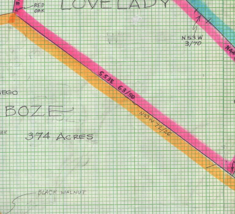
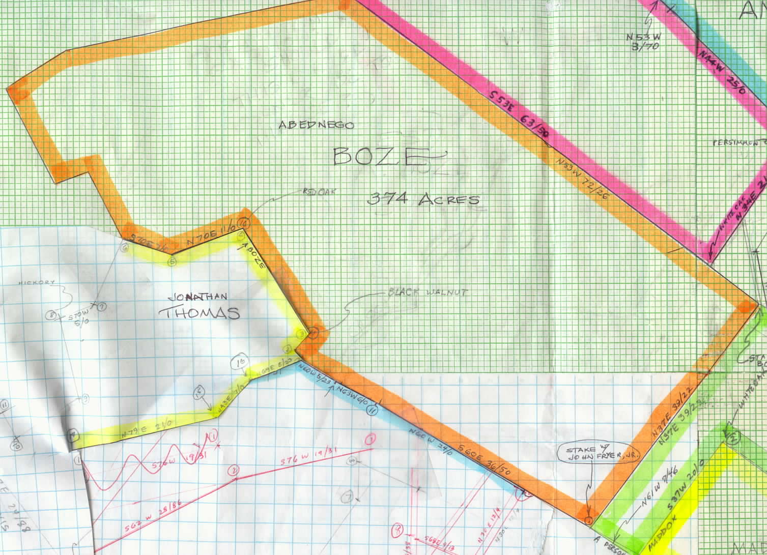
SEGMENT FIVE:

(Plat 14)--William Lovelady owned 176 acres of Crowson's Cove. Cove Creek crossed his land at about its center. His nearly rectangular plat appears here with a mauve border.


(Plat 15)--Evidently John Friar, Jr. had owned quite a bit of land adjacent to and south of Veach and Boaz (shown as Boze here), but by 1807 he had sold most if not all to several different people, including this 74.75-acre L-shaped tract shown in green, to Joshua Sims.


(Plat 16)--William Maddox also owned 53.25 acres of what had been John Fryer's land. This almost triangular plot is represented here in yellow.


.
SEGMENT SIX:

(Plat 17)--By far the largest single parcel of ground in the Cove we've seen was that of Abednego Boaz' 374 acres, shown bordered in orange. Cove Creek crosses it from southwest to northeast (for some reason I erased the creek lines, but you can still see them going through the word "black" in "black walnut" and through the "s" in "Acres").

(Plat 18)--I knew something was wrong with the data I have for Jonathan Thomas, as I was not able to make the lines meet.  As it turned out, the surveyor, Mark Moore, wrote his instructions incorrectly. Can you see the penciled line extending generally SSW from the point on Boaz/Thomas line where I stopped the yellow? Can you see that had I gone generally NNW instead, that it would continue coinciding exactly with the Boaz line? I fixed that on the main map (see next segment, below), and the lines matched up perfectly! This shows that Moore mistranscribed his own notes, recording "south" for "north" on Thomas' deed. 

[John M. Gwin Note, Oct 2013: A descendant of Jonathan Thomas has contacted me.  She's getting ready to do more research on JT's line and has invited anyone who would like to share data to contact her:  shawnee45 at msn dot com .]


(Plat 19)--I had a similar problem with the William Davis property (started here in blue), but now I've completed its map, below, as well. (Wm. Davis, you may recall from plat number 12 above, purchased the three acres of land for the Wear's Cove Baptist Church congregation [see no. 12 above].) 

.
SEGMENT SEVEN:
 

(Plat 18)--See what I mean about that line going north instead of south for Jonathan Thomas' land?  Now it all matches up. 

[John M. Gwin Note, Oct 2013: A descendant of Jonathan Thomas has contacted me.  She's getting ready to do more research on JT's line and has invited anyone who would like to share data to contact her:  shawnee45 at msn dot com .]

(Plat 19)--You can also now see that the problem I had with the William Davis property is solved. And while Person Davis' plat is not yet correct, those parts shown in pink are, leaving a very interesting almost triangular piece of "Vacant Land" in the middle. I look forward to comparing this to the today's map of the Cove and perhaps finding out why this land was not purchased.

In the Addenda section below, I have published below the incomplete (Plat 20) of Person Davis (started here in pink) and the complete (Plat 21) of Susanna Richardson, which fits against the western side of Person Davis' land.


 .
.
ADDENDA
mmmmmmmmmmmmmmmmm.mmm

This property belonged to a Parsons (Person?) Davis. I suppose he was related to the William Davis living next door to the eastsoutheast (Plat 19). I've not been able to find the error that is keeping me from connecting the lines in this survey, but you can see, from the three pink segments, that it certainly does connect to the Jonathan Thomas land, vacant land, and William Davis land, north to south, respectively.

To the southwest (bottom left), you can see my sketch of the Susanna Richardson property which she had just sold to David Denton. Denton, you may recall, married Elizabeth Gwin, whom I believe to be the daughter of Isham Gwin (Segment 3, Plat 7, above).

A map of the Richardson/Denton property appears below.

David Denton purchased this 36.5-acre plat from Susanna Richardson sometime before, I assume, the 16 Mar 1807 survey date. Compare this map to the one above to see how it connects to the Parsons Davis plat.
An Ezekiel Johnson owned this eighty-seven-and-a-half-acre plat. Our only clue as to where in the cove it was located are the two orange sides which were shared borders with a property of Mary Renfro. I have a very light, illegible (in places) copy of the Renfro deed, but I've not yet been able to draw the map or tell where in the cove it was loctaed.


Some Good Correspondence

[John M. Gwin Note:  The following genealogical info was sent to me by Mr. Edd Clardy of Columbus, MS, in Nov 2009, and I post it here as an aid to any Crowson descendants.]

Descendants of Aaron CROWSON

Generation No. 1

1.  AARON5 CROWSON  (WILLIAM SR.4, JOHN3, WILLIAM C.2, ROBERT (CROWDSON)1) was born March 16, 1777 in Sevier Co. TN., and died 1849 in Sevier Co. Tn..  He married JANE BARNES.  She was born Abt. 1775 in Servier Co. TN., and died 1849.
   
Children of AARON CROWSON and JANE BARNES are:
    i.    SARAH6 CROWSON, b. September 10, 1802, Sevier Co. TN..
    ii.    HULDA CROWSON, b. February 19, 1804, Sevier Co. TN..
2.    iii.    ELIZABETH BETTY CROWSON, b. September 17, 1805, Sevier Co. TN.; d. 1885.
    iv.    MARY POLLY CROWSON, b. February 18, 1808, Sevier Co. TN.; m. MICHAEL HOWELL.
3.    v.    RICHARD WEST CROWSON, b. July 08, 1810, Sevier Co. TN.; d. July 27, 1887, Sevier Co. TN..
    vi.    LYDIA CROWSON, b. Abt. 1812, Sevier Co. TN..
    vii.    AARON CROWSON.

Generation No. 2

2.  ELIZABETH BETTY6 CROWSON (AARON5, WILLIAM SR.4, JOHN3, WILLIAM C.2, ROBERT (CROWDSON)1) was born September 17, 1805 in Sevier Co. TN., and died 1885.  She married JAMES BURNES. 
   
Child of ELIZABETH CROWSON and JAMES BURNES is:
    i.    RICHARD7 BURNES.

3.  RICHARD WEST6 CROWSON (AARON5, WILLIAM SR.4, JOHN3, WILLIAM C.2, ROBERT (CROWDSON)1) was born July 08, 1810 in Sevier Co. TN., and died July 27, 1887 in Sevier Co. TN..  He married NANCY ALLEN MATTOX.  She was born 1818 in Tennessee.

More About RICHARD WEST CROWSON:
Burial: July 1887, Sevier Co. TN.
Census: 1850, Census sevier Co. TN.
   
Children of RICHARD CROWSON and NANCY MATTOX are:
    i.    MARY C7 CROWSON, b. November 27, 1838, Tennessee Servier Co..
    ii.    MARTHA JANE CROWSON, b. January 10, 1841, Tennessee; d. 1854.
    iii.    WILLIAM CROWSON, b. September 26, 1843; d. 1848.
    iv.    JAMES WELLS CROWSON, b. October 06, 1848; d. 1850.
    v.    JOSEPH CROWSON, b. March 21, 1851; d. 1905.
    vi.    RICHARD WEST CROWSON, b. January 24, 1854; m. MARTHA LOUISA KING.
    vii.    SARAH ELIZABETH CROWSON, b. December 31, 1857, Sevier Co. TN.
    viii.    NANCY CAROLINE CROWSON, b. January 08, 1860.


[John M. Gwin Note:  And here I put this data into my own format:]

20.00--Robert Crowdson, b. unk.; d. unk.; bd. unk.; m. unk.; at least one ch.

21.00--William C. Crowson, b. unk.; d. unk.; bd. unk.; m. unk.; at least one ch.

22.00--John Crowson, b. unk.; d. unk.; bd. unk.; m. unk.; at least one ch.

21.00--William Crowson, Sr., b. unk.; d. unk.; bd. unk.; m. unk.; at least one ch.

22.00--Aaron Crowson, b. 16 Mar 1777 in Sevier Co., TN; d. 1849 in Sevier Co. TN; m. unk. date/place to Jane Barnes (b. ca. 1775 in Sevier Co., TN; d. 1849; bd. unk.); 7 known ch.

23.01--Sarah Crowson, b. 10 Sep 1802, Sevier Co., TN; d. unk.; bd. unk.; m. unk.; unk. ch.

23.02--Hulda Crowson, b. 19 Feb 1804, Sevier Co., TN; d. unk.; bd. unk.; m. unk.; unk. ch.

23.03--Elizabeth "Betty" Crowson, b. 17 Sep 1805, Sevier Co., TN; d. 1885; m. unk. date/place to James Burnes (b. unk.; d. unk.; bd. unk.); unk. ch.

24.00--Richard Burnes, b. unk.; d. unk.; bd. unk.; m. unk.; unk. ch.

23.04--Mary "Polly" Crowson, b. 18 Feb 1808, Sevier Co. TN; d. unk.; bd. unk.; m. unk. date/place to Michael Howell (b. unk.; d. unk.; bd. unk.); unk. ch.

23.05--Richard West Crowson, Sr., b. 8 Jul 1810, Sevier Co., TN; d. 27 Jul 1887, Sevier Co. TN;  bd. Jul 1887, Sevier Co. TN; m. unk. date/place to Nancy Allen Mattox (b. 1818 in TN; d. unk.; bd. unk.); 8 known ch.; [Census: 1850, Census Sevier Co. TN]
   
24.01--Mary Crowson, b. 27 Nov 1838, Sevier Co., TN; d. unk.; bd. unk.; m. unk.; unk. ch.

24.02--
Martha Jane Crowson, b. 10 Jan 1841, TN; d. 1854; bd. unk.; m. unk.; unk. ch.

24.03--
William Crowson, b. 26 Sep 1843; d. 1848; bd. unk.; m. unk.; unk. ch.

24.04--
James Wells Crowson, b. 6 Oct 1848; d. 1850; bd. unk.; m. unk.; unk. ch.

24.05--
Joseph Crowson, b. 21 Mar 1851; d. 1905; bd. unk.; m. unk.; unk. ch.

24.06--
Richard West Crowson, Jr., b. 24 Jan 1854; d. unk.; bd. unk.; m. unk. date/place to Martha Louisa King (b. unk.; d. unk.; bd. unk.); unk. ch.

24.07--
Sarah Elizabeth Crowson, b. 31 Dec 1857, Sevier Co., TN; d. unk.; bd. unk.; m. unk.; unk. ch.

24.08--
Nancy Caroline Crowson, b. 8 Jan 1860; d. unk.; bd. unk.; m. unk.; unk. ch.

23.06--Lydia Crowson, b. ca. 1812, Sevier Co., TN; d. unk.; bd. unk.; m. unk.; unk. ch.

23.07--Aaron Crowson, b. unk.; d. unk.; bd. unk.; m. unk.; unk. ch.


[John M. Gwin Note:  Today, 3 Dec 2009, I received some newspaper clippings from Mr. Clardy which I have transcribed below.  The first is
an article written for The Pigeon Forge Anvil, Pigeon Forge, Tennessee, by Ms. Diane Wilkinson, April 20, 1972, page 1B, with some additional notes.  The second is a followup article to the first also written for and by The Pigeon Forge Anvil, also sometime in 1972.]


 1B   The Pigeon Forge Anvil  April 20, 1972

From Indians to Boy Scouts:
178 Years of Wear's Valley History


By Diane Wilkinson
of The Anvil staff

"The first time I travelled Wear's Valley Road from Pigeon Forge, I rejoiced in the beauty of the winding road, the steep slopes, tall trees, and the pounding, wild cascades.  As the car ascended the mountain past the cascades, I noted to my passengers that it had been a worthwile side trip to the Park.  They agreed.  We all thought we had seen everything the back road had to offer in the way of unique beauty.  But we were, of course, totally wrong.

We were still discussing the thrill which living over the cascading falls might hold when a new and more unusual scene stretched out before us.  The smooth, pastoral greenness of Wear's Valley stopped all talk of waterfalls.

So it probably did in the spring or summer of 1794 when two men from what is now North Carolina rode their mounts down approximately the same route from Wear's Fort (now Pigeon Forge) to see if they could find a more pleasant place to live.  The sight they beheld as they crossed the last rise before the valley was probably vastly different from the one I came upon, but it was a valley, nonetheless.  Among all those peaks it could not have been less refreshing and inviting than it is today.

As Aaron Crowson and Perceval Percefield soon discovered, the refreshment and promise of good farmland was not without hazard.  It turned out that Wear's Cove was already occupied.  Understandably, Cherokee Indians had also been attracted to
the rich soil.  Thus, when Crowson and Percefield staked their claims to some land along what is now Valley View Road (near Clabo's Store), they should not have been surprised to find themselves involved in a skirmish with the Indians within a short while.

 Little is known about the skirmish itself--not even who attacked whom and why--but for Percefield, it was the end of a dream.  The young man in his early 20's was killed, and his partner rode to Wear's Fort to get help from settlers.  The settlers returned with Crowson to bury Percefield in a spot now called the Old Crowson Cemetery.  Its location is in a pasture amid some trees on the land directly across from Clabo's store and in back of the house now occupied by Mrs. W.W. Crowson.  Mrs. Crowson's husband, William, was the great-grandson of the first white man to settle in what is now Wear's Valley.

After Percefield was buried, Crowson set to work clearing the land and constructing a home so that he could bring his wife down from North Carolina (wrong--possibly Green Co., Tenn.).  He was 18 years old and was undoubtedly eager to begin the life he had dreamed of there in that inviting  wilderness.  The Indians, legend had it, were chased away by the white men, and there is no hint that white settlers were attacked thenceforth.

According to the tale passed down the family tree from the first Aaron to the
Mrs.
Crowson who now lives by the graveyard, the young settler prospered, brought in his wife, had children, and even acquired a few slaves.  The slaves are buried in the Crowson graveyard along with Percefield, many members of the Crowson family, and various other residents of the valley.

The 1830 Sevier County census lists a 50-60-year-old Aaron Crowson, his wife, also in her 50's, and children and/or grandchildren, ages 5-20.

At least one of Aaron's children--a son, Richard--spent his life on the old homeplace and raised a family of three boys and three girls.  The girls all left the Valley; one went to Sevierville as a McMann, one to Townsend as a Wear, and one to the Douglas Dam area as a Yett.

Richard's sons (Aaron's grandsons) were Aaron, Richard West (always called West), and Joseph.  The latter two are buried in Crowson Cemetery along with one of West's sons, William.  West's other son, Earl, is buried at Shiloh Cemetery near Sevierville.

William, the husband of the lady who kindly talked to me about this grand history, died seven years ago.  Descendants of the first Aaron Crowson now living in Wear's Valley are his great-grandsons, Loy and Walter.  Their father was West's brother Aaron ("Uncle Aaron", as he was known to many in the Valley).  Some descendants of Loy and Walter also live near the old
homesite, but of William's five children,
only one still lives in the county.

I asked Mrs. Crown Crowson why so many left the beautiful valley which their ancestor settled 178 years ago.  The gracious lady smiled.  "Maybe," she said, "they would have stayed if it had been named Crowson's Valley."  According to Mrs. Crowson, it is a family joke that the Valley was robbed of its rightful name.

Mrs. Crowson admitted knowledge that Wear's Valley took its name from a man named Wear, one of those who accompanied Aaron Crowson back to the Valley in 1794 to bury Percefield.  Legend has it that that it was after clearing brush for the burial that Wear commented, "Since I am the first man to cultivate this valley, it should have my name."  If Aaron Crowson objected, we can be sure it did him no good. 

(Note by this writer--It appears presumptuous that Wear would declare that the valley should named after himself.  More appropriate, since Percefield had given his life, would have been "Percefield's Valley".)

"Another thought that has stuck with the family is that we could be called thieves for taking the land away from the Indians.  My sons have often commented on that," Mrs. Crowson said.

When I took out my camera to capture her singularly pleasant smile for publication, she protested.  "I would
rather wait till the graveyard is back in good shape.  Then I
will show you around it."  Mrs. Crowson has been concerned about the disrepair of the graveyard for a good while and is very pleased that the Wear's Valley Boy Scout Troop is now undertaking a restoration job on it.

The Crowsons tried to keep the whole graveyard in good shape for many years, but during recent times they could only manage the care of plots on the side where the Crowsons and Mr. Percefield are buried.

Among the names other than Crowson that mark plots in the graveyard are Bryan, Broyles, Cooper, England, and others not so legible.  Dates of burial rand from 1794 to 1964.  One of the simpler but new stones reads:


Perceval (Percefield)
Killed by the Indians
1794
First Burial in Wear's Cove


It lies near the very old and crude tombstone which originally marked the site of Mr. Percefield's burial.  Just beyond it is an old and larger stone marking the grave of Aaron Crowson (Born March 18, 1777; Died February 18, 1849).

They were two adventurers to whom we all owe a thought of commendation for their courage, their wanderlust, and especially for their dreams. 

Mrs. Lillian Hart, a descendant of Aaron Crowson, found Aaron's date of birth, 18 March 1773, recorded in an old Bible owned by Dr. Wayne McCulley of Cleveland, Tennessee. Mrs. Hart thinks the marker giving the date as 1777 was a repacement of an older marker, and an error was made in copying.

Several sources state that Aaron Crowson and his wife, Jane Barnes, had three daughters and seven sons, but Mrs. Hart found Bible records that list four daughters and one son:  Sarah, Hulda, Elizabeth, Mary (Polly), and Richard West Crowson.  There could possibly have been other children.  [John M. Gwin Note:  The genealogical data Edd Clardy sent, above, lists seven children (five girls and two boys): Sarah, Hulda, Elizabeth, Mary, West, Aaron, and Lydia.]

Ms. Inez Burns (History of Blount County, Tennessee) states that a petition from Aaron Crowson in the Tennessee Legislature, dated 10 June 1820, stated that his father William Crowson and a Mr. James Ross both possessed the right of occupancy and pre-emption to a tract of land in Cades Cove, dated 6 February 1796.  Ms. Burns is a granddaughter of Elizabeth Crowson and James Burns.


The Pigeon Forge Anvil  1972 (day and month missing--possibly summer or fall)
Legend of Crowson's Cove may be older than thought
     This spring, the Anvil carried a feature story about the Crowson Cemetery in Wear's Valley, the site of a tombstone which marks the burial place of the"first white man buried in Wear's Cove."  After reading that article, Glen Hatcher of Gatlinburg disclosed  to the Anvil that he has papers and family legends substantiating the story about Aaron Crowson and Percefield and their settlement of the Valley.
     However, Hatcher reports that these papers -- belonging to William Hatcher, Crowson's brother-in-law -- indicate that Wears Cove  (or Crowson's Cove, as it was sometimes called in the late 18th century) was settled somewhat earlier than 1794, and that the date of Percefield's death as listed on the modern tombstone might be erroneous.
     "The way I understand it is that in the first year -- the year Crowson and Percefield arrived the Valley and
the year Percefield was killed--no homes were built.  In the second year, Crowson's home was built, and in the third year, Hatcher's home was built.  And I have records which show that William Hatcher paid County taxes as early as 1794.  So that must have been at least three years after the valley was first settled.  That would mean that Crowson's Cove was first claimed by white men in 1791 or earlier, he says.
     Thus, Hatcher believes that the date of Mr. Percefield's death should be marked as 1791 or earlier, rather than 1794.
     The text of the earliest tax receipt in Glen Hatcher's possession reads, according to him, "Rec. of William Hatcher his County tax for Jefferson County in full for 1794.  John Reno, Col." 
     Crowson's Cove was at that time part of Jefferson County.

This relatively new grave marker in Crowson's Cemetery in Wear's Valley may be 'out-dated.'  Glen Hatcher of Gatlinburg, a descendant of the original settlers of Wear's Cove, possesses old papers which indicate that Mr. Percefield met with his death as early as 1791.


From the Wikipedia page at http://en.wikipedia.org/wiki/Wears_valley


History of Wears Valley

Wears Valley is named after Samuel Wear (1753-1817), a Revolutionary War veteran who erected a fort near the entrance to the valley in what is now Pigeon Forge. The original name of the valley was "Crowson Cove," after its first settler, Aaron Crowson (1774-1849). While no one is sure why its name changed, the valley was using its current name by 1900.

Crowson arrived in Wears Valley from North Carolina in 1792 along with his friend, Peter Percefield. This was a period of elevated strife between the Cherokee and the fast-encroaching Euro-American settlers. Wear's Fort was attacked in 1793, with Wear leading a punitive march against the Cherokee village of Tallassee shortly thereafter. In May of 1794, Percefield was killed in a Cherokee attack. Crowson rode to Wear's Fort to get help, but the Cherokee had fled by the time he returned. Several settlers marched onward to Great Tellico to the west, where they murdered four Cherokee while they slept. Percefield was buried on a hill in the eastern half of Wear Cove in what is now Crowson Cemetery. Later that year, Crowson received a land grant for this plot of land.

Along with Crowson, other early settlers in Wears Valley included a Revolutionary War veteran named William Headrick (1744-1839), who arrived in 1821, and John Ogle (1788-1841), a War of 1812 veteran and son of the first settlers in Gatlinburg. Another War of 1812 veteran, Peter Brickey (1769-1856), arrived in 1808. [John M. Gwin Note: I believe that Brickey was in the Valley before 1808. I have a copy of the deed to his farm (see Plat Map #11, above) which Mark Moore surveyed in the summer of 1807.] Brickey operated a large farm and distillery in the valley until his death in 1856. The log house he built shortly after his arrival still stands in Smith Hollow (between Wears Valley and Townsend) and is listed on the National Register of Historic Places.

Like many other farms in Wears Valley, the Brickey farm was ravaged by the U.S. Civil War. Isaac Trotter, who operated the iron forge at Pigeon Forge reported a Cherokee raid in Wear Cove in 1864. Earlier in the war, a Union army passed through the valley en route to dislodge the troops of Will Thomas who were entrenched in Gatlinburg.

Sometime after the war, Alfred Line (1831-1897) established a farm at the base of Roundtop Mountain, near the southern half of Wear Cove. [John M. Gwin Note: I believe that this is part of the same farm where my gggg-grandfather, Isham Gwin, was granted and bought 249 acres (see Plat Map #7, above).  He sold the farm to an unknown buyer when the Gwins, Veatches, Dentons, and others moved to Indiana before 1820.  Mr. Line must have bought it from that buyer or a subsequent one.] Line Spring, a clear mountain spring which flows down from the slopes of Roundtop, gave its name to a small recreational area that developed in this part of the cove. In the 1880s and 1890s, mineral-rich mountain springs were thought to have health-restoring qualities, and provided an early form of tourism for the mountain regions. In 1910, D. B. Lawson, the son of a circuit rider who had purchased the Line farm, constructed the Line Spring Hotel. The hotel boosted the valley's economy by providing a market for local farmers.


From: Steven Thomas shawnee45 at msn dot com
Date: February 16, 2011
To: <jmcdgwin@zianet.com>
Subject: Crowson's Cove

You have a great site. Thank you for sharing.  We are from the Jonathan Thomas lineage of Crowson's Cove.
Jonathan was Aaron Crowson's uncle, but more his own age. Jonathan was born in 1769 Bladen Co., N.C., and was the baby brother of Mary Thomas-Crowson.
Jonathan migrated to Ball play area of Monroe, Co., Tennessee.  We have reference of him using Isaac Thomas of Sevier Co. for legal work.
In the future if you have anyone looking for the Thomas family of Eastern Tennessee, would you share our email address?  Thanks so much.

Karen Thomas