Item 01--Let's
put
a
timeline together based on the
various items below:
1830--
1831--
1832--
1833--
1834--
1835--
1836--
1837--5 Aug: The weekly
(Saturday) Cahaba newspaper, the Southern Democrat,
advertises some land sales of
plantation properties within
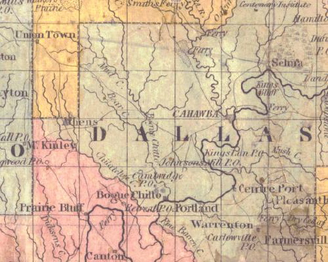
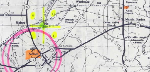
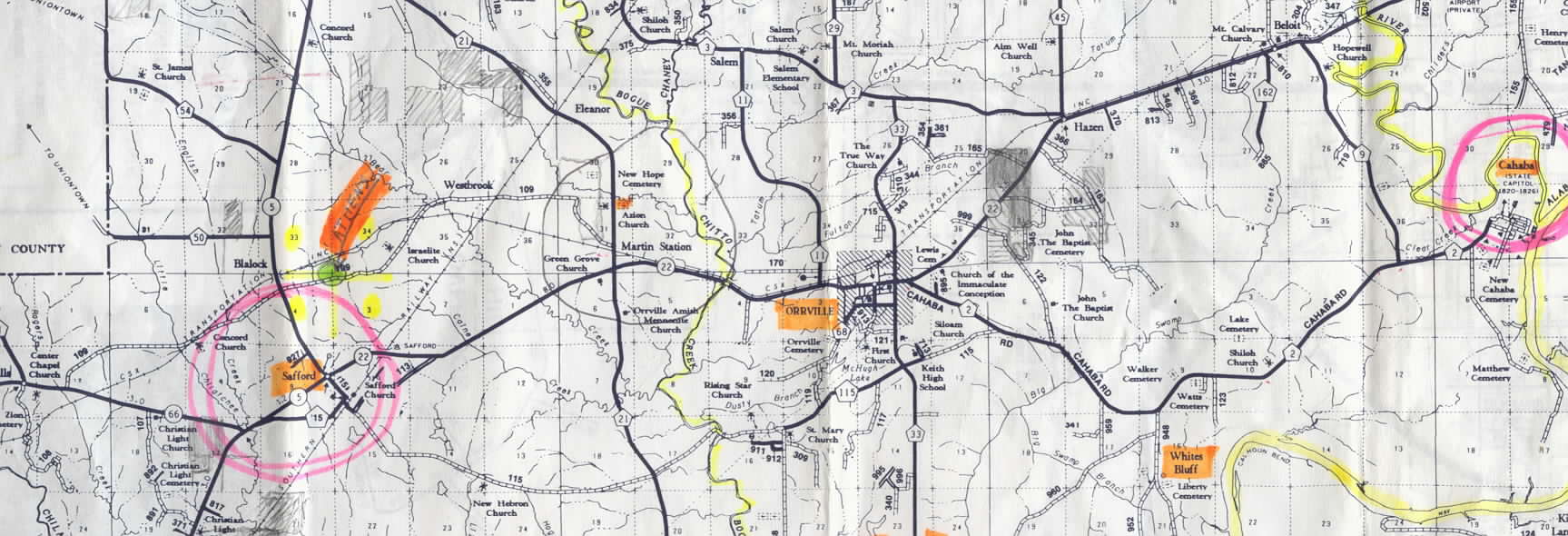
three miles of Athens
1838--31 Oct.: Mary Jane Gwin
is born in Dallas Co. to Isom and Mary
B. Wilson Gwin--at Athens?
1839--
1840--Isom Gwin "(becomes)
religious in 1840, and (unites) with the Protestant Methodist
Church of which he (lives) a member till his death" (from his
gravestone).
I
believe
that
it was this church that existed at or
near Athens--now Martin's Station--since the
St. Luke's Episcopal church of Cahawba wasn't even built until
after Isom died. Perhaps this Athens Protestant Methodist
Church burned or was otherwise destroyed around 1875-6, and
its congregation offered to take the St. Luke's building.
1841--An Isaac Ransom
McELROY, is born 6 Apr 1841
at Athens in Dallas County, Ala; this from Item
03.
1842--
1843--Martha R. Gwin is
born 5 Apr 1843 (but gravestone says
1844) in Dallas Co. to Isom and Mary B. Wilson Gwin. According
to the letter (item 4), Martha was raised in Athens. This means
her parents and sister lived there as well, of course.
1844--
1845--
1846--
1847--
1848--
1849--
1850--2 Sep, Mrs. E.M. Wilson
gives birth to a daughter, Elizabeth Ann Wilson (see
item 7 below) in/near Athens.
--------18
Sep,
M & M David Journey sell five lots on Main St. in Athens, Dallas Co., AL, to Isom
Gwin and his brother-in-law, E. M. Wilson (see
item 5 below).
1851--17 Jul, Elizabeth Ann
Wilson dies and is buried; her
grave is located at what is today Martin's
Station, AL, and what I for a while believed was then Athens, Dallas Co., AL.
1852--
1853--Dec 7 (17?): When Martha
is age nine or ten, her father, Isom Gwin, dies--at
Athens--and is buried--near Athens at the cemetery of
the church where he was a member. Isom's
grave is located at what is today Martin's
Station, AL, beside that of his daughter, Mary Jane
Gwin (Mrs. William J.) Smith, and that of his niece, Elizabeth
Ann Wilson.
--------22
Dec.: Mary Jane Gwin, 15-year-old daughter of the
late Isom
Gwin, is married to William J. Smith.
1854--The new building of the St.
Luke's Episcopal Church is consecrated at
Cahawba where it will stand for 22 years, until 1876, when it
will be moved to its present-day location at Martin's
Station., where I believe there was another church, the
Protestant Methodist Church of which Isom Gwin was a member,
across the road from which was--and still is--its cemetery. [JMG Note: This St.
Luke's Church was recently purchased and, in 2006, was
dismantled and returned to Cahawba where it is to be
rebuilt.]
1855--15 Jan, William J.
Smith, Administrator of the Estate of Isom Gwin,
deceased (son-in-law of the deceased) of Dallas Co., AL, sold
to attorney John A. Lodor the land in the town
of Athens, Dallas Co., AL
(see Item 6).
1856--
1857--
1858--
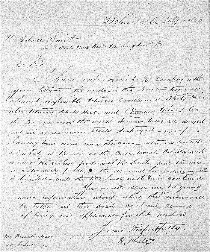
1859--Jan. 28, Wm. J. Smith
and Chesley Gwin, Isom's youngest brother, are in
business in Liberty Hill, AL (see item 08 below).
1860--Sep 7: At age 16 (17?), Martha
marries Madison "Matt" Holley in Athens (or possibly in the
Methodist church three miles east).
1861--
1862--
1863--
1864--
1865--
1866--
1867--
1868--
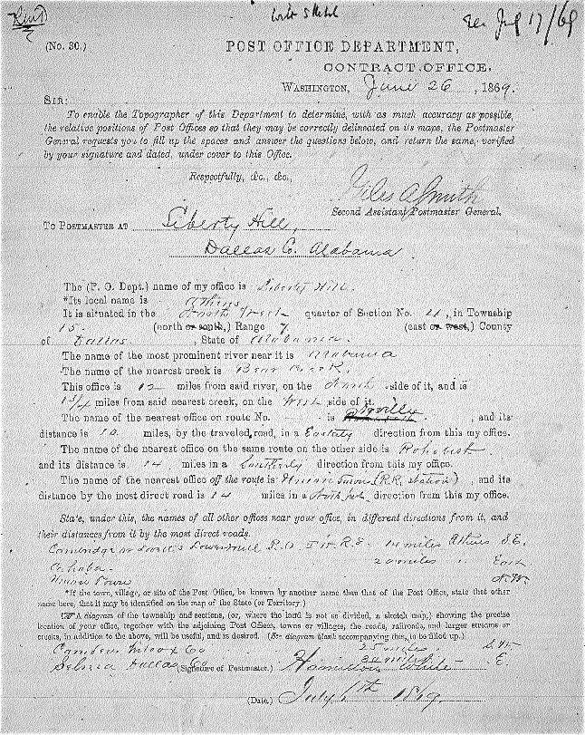
1869--
1870--At census time, William
J.
Smith and his wife, Mary
Jane
Gwin Smith (daughter of Isom Gwin) and son, Robert
Isom Smith, are living in the census district of Liberty
Hill Post Office.
--------A
Stephen MEGGS and Penelope ETHEREDGE MEGGS were shown living
in Severe Beat, Perry County, AL in the 1860 census and then were shown to be living in Athens, Dallas County, AL in the 1870
cenus (see Item 10 below).
1871--Mary Jane Gwin Smith,
wife of Wm. J. Smith, dies and is buried beside her
father, Isom Gwin, at what is today Martin's
Station, AL, and where I once believed was then Athens, Dallas Co., AL.
1872--
1873--
1874--
1875--
1876--The building of the St.
Luke's Episcopal Church is moved from Old Cahawba,
the site of Alabama's first permanent capital, to what is
today Martin's Station to protect it from floodwaters. But why
was it moved to this particular spot? Was it thought that it
would be protected here near this Town of Athens? Did the
"Protestant Methodist Church" (see
Isom
Gwin's gravestone) of Athens burn and its
congregation purchase and move this building to their church's
former site? This latter question is based on the fact that
the cemetery across the road from the St. Luke's Church was in
use before St. Luke's was even built in Cahaba, so another
church was likely located there. [JMG Note: This St.
Luke's Church was recently purchased and, in 2006, was
dismantled and returned to Cahawba where it was rebuilt.]
1877--
1878--
1879--
1880--